This article/blog post was written and published by Linden Alexander Pentecost, and was published quite early in the morning on the 19th of March 2026, after an unrelated article/blog post was published on this blog even earlier this morning about symbols at the Borrowdale Yews and the Borrowdale Yews themselves & related topics. Tomorrow I will also publish an unrelated PDF-book via a different website, where I will discuss what a witch said about symbols, and much much more, I also published an unrelated different PDF book yesterday. This article on this page is unrelated to and separate from any and all of my other publications, no AI was used in this publication, this publication was published in the UK on this UK website, & the author is from the UK & a resident of the UK, this article also contains two photos, with descriptions above them, the photos were also taken by myself the author. This article contains a total of 1040 words.
Last year I spent some time in Vantaankoski, close to Vantaa in southern Finland. I went there because I thought that the Vantaankoski weir walls may have exhibited polygonal masonry, but having been there I can say that they do not exhibit I think true polygonal masonry (unlike many other sites in southern Finland). Having said this, there may be true polygonal masonry in the foundations of the road bridge over the river, whereas I was mainly looking at the dam walls built across the river as part of the Mill structure. I have discussed many other examples of polygonal masonry in Finland in other publications, for example the polygonal masonry at Vanhankaupunginkoski, Mannerheimintiensilta, Hämeenlinna, Suomenlinna and elsewhere, with different parts of this work published in different publications including one on Hämeenlinna on this website, with others elsewhere.
It was an interesting day. Rather than following the path to the site, I kind of just walked down a path on the side of a main road, then quickly jumped (not literally) down into the bushes and forest in the general direction of the Vantaankoski weir, although I ended up in the wrong place. I did eventually find it though, with the help of someone.
It was an eventful day that sort of, became the night, basically resulting in me running towards a train station late at night along a path on a roadside, expecting to go under a bridge and to a station, but I soon instead found myself in somewhere that just, didn't seem like the kind of place where one would find a train station, I was on a road in a forest, with a few houses to my left, and an owl tooted in the background as if to say confirm my miscalculation. I wandered around for a good while having a nice conversation with someone I had met in Finland and had met with earlier that day, resulting in a 4:40 AM explore of a concrete tunnel, in which we played Finnish music on our phones. Then I got a bus to Itäkeskus in Helsinki, watching a beautiful red-orange sunrise, and got a metro train from there back into Helsinki, where I got a baguette, rang my friend, and then slept.
The Vantaankoski Rapids are an archaeological site, with some of the mills on these rapids dating back to the 1500s, but people were present on the Vantaa River in prehistoric times, and one wonders about possible continuity.
The symbol or marking in question, is a marking on a non-submerged part of the rock surfaces which form parts of the river bed, and is located just beneath the road bridge and sort of below and back a little from the bridge on the left bank of the river, if you are facing upstream. The symbol is a triangular symbol carved into the rock. I cannot discount the possibility that it could be the base where some kind of instrument or machinary, but I do not think so, as the symbol does look very old. There are some other symbol carvings similar to this found elsewhere in Finland, although I cannot off the top of my head remember exactly where, but when I find a reference to them I will (I know I have a reference somewhere). The other symbol I saw a picture of was more anchor-shaped though, and also resembled one of the Sámi symbolic language symbols. From what I understand, that symbol symbolically meant or conveyed that the place in question, which I believe was an island, was a place of fishing, or perhaps in a more animistic sense, also a place associated with the deities of fishing, which the symbol may have been depicting.
I wonder if perhaps the triangular symbol at Vantaankoski might also be there to indicate that that place is associated with fishing in some way. The coordinates of the symbol/carving are I think at around: 60.293257, 24.865743 .
Photo below: the rock surface upon which the triangular symbol is visible, note that the rock is made of granite and that the carving of a symbol, if that's what it is, seems to be very old. I could not see any evidence of recent tool-use either, nor do I think that this marking is of natural origin.
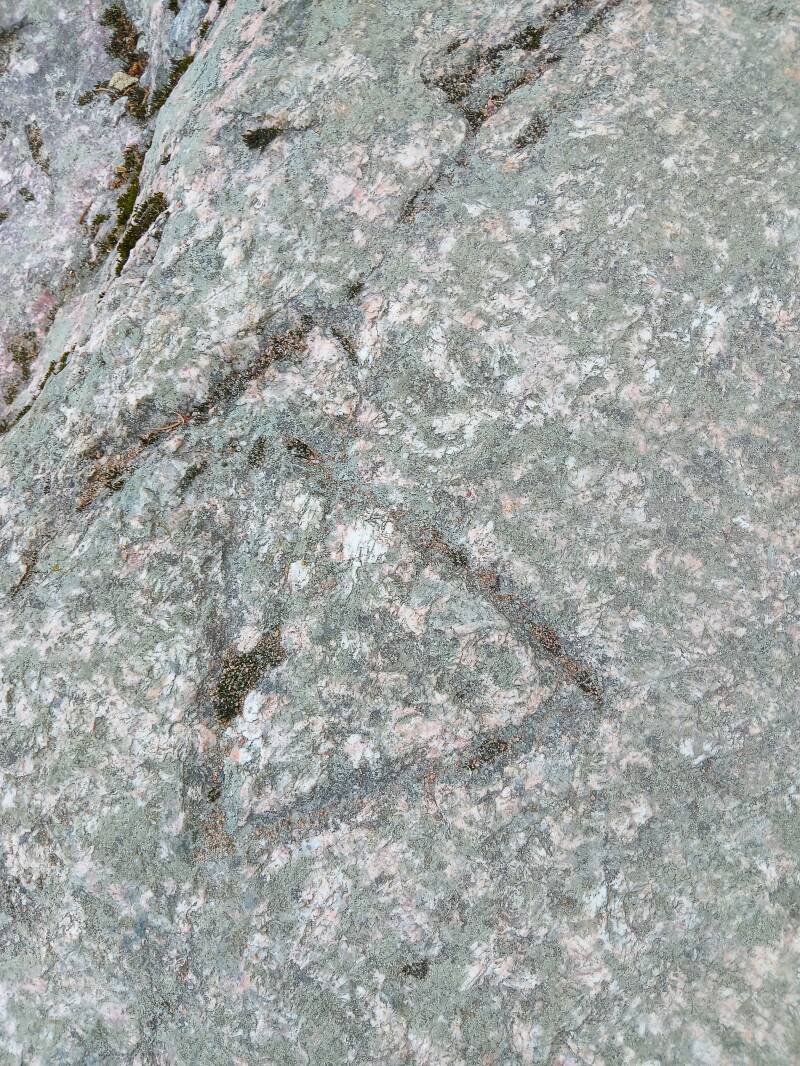
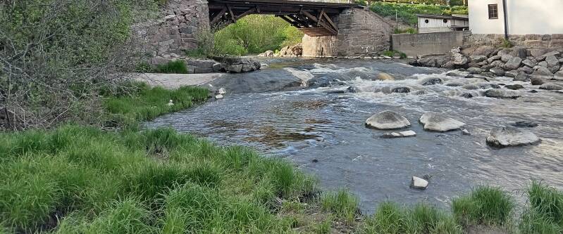
Photo below: the photo below was taken from I think, around the location of where the carving is. Note the road bridge centre image, with what may or may not be true polygonal masonry at its base. Most of the masonry uses mortar, but this may have been added later, and it is possible I think that parts of the left side in particular may be polygonal masonry in a truer sense, but I am unsure. Note that the road going over the bridge is a smaller road and is not the larger E18 road which crosses the river slightly further up.
I hope that this article was an interesting read, thanks for reading. This article is dedicated to the stone age peoples who fished the river thousands of years ago, and to the people of the Vantaa region today.
Add comment
Comments