This article/blog post was written and published by Linden Alexander Pentecost, and was published on the 9th of April 2026. The 6 photos in this article were also taken by me the author, and like the text in the article have not been published before, two of them show a few of the external archaeological features discussed, the other four markings show apotropaic markings within Dunald Mill Cave - please read my detailed comments about this cave and why it is dangerous to visit it. This article/blog post is unrelated to and separate from any and all of my other publications. No AI was used in any part of this publication nor in any of my written works. This article was published in the UK and on this UK website, I, the author, am also from the UK and live in the UK. The photo descriptions in Italics contain information not in the main text. The photos themselves are also important alongside the main text and the text in italics. This article/blog post contains a total of 2816 words. At the end of this article I discuss some other topics related to archaeology and language but not specifically to Nether Kellet, all parts of this article are relevant and important.
Recently I visited Nether Kellet, a village close to Carnforth in Northern England. When I first visited this area in 2023, I noticed some somewhat-megalithic walls, and we explored them. I will discuss these in a future blog post, but here will write about the recent visit, where we went back to one of the same areas, looked at what appears to be a prehistoric earthwork embankment and two possible cairns, and other features, and I went into Dunald Mill Cave, a very dangerous cave, where I found a couple of - what are probably apotropaic markings or "witch marks". I will go on to discuss these features soon, but first I want to discuss some other features I have noticed on the LIDAR map, including a feature to the north closer to Carnforth.
When looking at the area on a LIDAR map, I also noticed two other features, which I would like to briefly discuss. These are what appear to be two rounded earthen mound features, around which can be seen several small circular shapes on LIDAR. I have not visited these, but others may find them interesting. They could perhaps be burial mounds of some kind, and I ask that people be very respectful of them. They are located on opposite each other, and between the two mounds run what appear to be two other earthen embankments, in addition to the one I actually visited - but it is also possible that these are geological features. There is a northwestern mound and a southeastern mound; the northwestern mound is located at the coordinates of: 54.12792, -2.73873, whilst the southeastern mound is located at the coordinates of 54.12703, -2.73730 . These are extremely interesting looking, and - if the aforementioned possible earthen banks are indeed earthen banks, then it would seem also that another set of parallel earthen banks are located a short distance to the west and are running in a generally northerly direction, whilst the other parallel embankments are running in a southwest to northeast direction. Between the two parallel earthen banks running north, is another possible earthen bank, also going north, which leads to another group of mounds, although these look more natural than archaeological from what I can see on the LIDAR map, these are located at the coordinates of: 54.12918, -2.74054 .
There is also a burial mound near Borwick, Carnforth, which is known about, and I have discussed a lot of other features of archaeology around Carnforth in other publications, but another feature I would like to discuss in this article - keeping with the subject of earthen embankments in this part of the article, is another interesting possible earthen embankment or possible ditch, visible on the LIDAR map, located at the coordinates of: 54.15746, -2.72948 , this possible embankment is also running in a southwest to northeast direction.
Now, back to the subject of the other embankment and possible cairns which I went to in person, which will be followed by the subject of apotropaic markings in the cave. The other embankment feature is located at the coordinates of: 54.10883, -2.77355, and is also running in a steeper southwest to northeast direction - although in this case the reason may be more physically geological. The embankment sits above a small, narrow, but deep valley, in an agricultural landscape. Rocks have been placed into the embankment, and they are exposed in places, giving the impression of a partially-hidden stone row, albeit not of huge stones, and similar features are found in parts of South Cumbria for instance. To the left of the northern part of this feature is what may be either a clearance cairn or burial cairn - if a burial cairn, it seems to have been robbed or has partially collapsed. Not far below it and slightly north is a natural spring, and further down the valley is another mound, possibly natural. The features to the north and west of here are those I will discuss in a future publication.
At the southern end of the embankment, it seems to split into an upper and lower section, with the upper section with its stones going in a more directly southerly direction, past a larger almost-megalith stone, and ending at, what is either a clearance cairn made of small megaliths, or which is a megalithic burial cairn, similar to other similar monuments in parts of Cumbria and Lancashire. To me, this feature does not make a great deal of sense to me as just being a clearance cairn, why would such large rocks be cleared to a point which is higher than most of the areas around it, and why would it be specifically created at the end of a likely ancient earthen feature?
I will show parts of this site in the photos below and I also discuss more on the site in the photo descriptions in italics above the photos, after which I will discuss the apotropaic markings in Dulnald Mill Cave & include 4 photos of them, after which I will discuss some other topics briefly.
Photo below: the possible somewhat-megalithic cairn located at the southern end of the embankment, the embankment being located at: 54.10883, -2.77355 . Note that the largest stone is to the left and what could be a kind of stone arrangement, cist or primitive passage tomb could be what we see going to the right of this larger rock, meaning that its entrance would have faced the valley. Note also the high location compared to the valley bottom visible on the upper right.

Photo below: a part of the embankment which leads to the possible cairn visible in the photo above, the other non-megalithic possible cairn I discussed close to this embankment is located behind where this photo was taken. Note the stone visible on the embankment in the photo and also the beautiful hawthorn trees, which seem, for some reason, to grow commonly at ancient sites in Lancashire and Western Cumbria.

On the same day I visited the site discussed above - I also visited Dunald Mill Hole, a cave, with an impressive but extremely dangerous entrance. This cave is unlike some others, in that one of its greatest dangers are the drops which suddenly appear. The are areas where giant boulders have fallen from the ceiling, and, going inwards into the cave, a person might think that the drop on the inner cave's side of the boulder might be the same as that on the sides facing the entrance, but on the inner side, the drops off some of these boulders appear out of no-where, there are cracks between boulders which have the same floor height as the area behind, but a bit further between the boulders and suddenly the groups stops, and in front is a dangerous drop of 15 feet or more to rock and fast flowing water. It is a very treacherous place and the rocks are also extremely slippery, roof falls are possible, and the cave can quickly flood, creating a drowning risk. I did get out okay, thankfully.
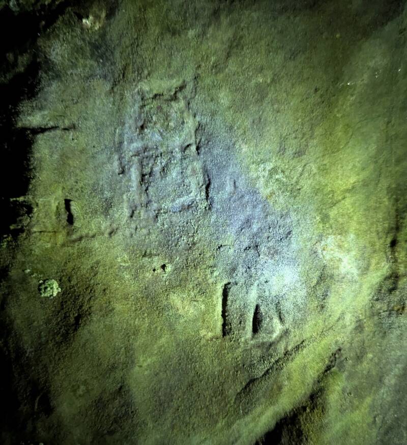
This cave would without doubt have held significance to the ancient peoples of that landscape. I was told by Tom Lord, the archaeologist, that there may be apotropaic markings in this cave, Tom also was the one to let me know about those at Jubilee Cave. I did not know where to look for them, I had been into Dunald Mill Cave once before about 6 or something years ago. I approached the large entrance from the left side, after a treacherous climb, approaching from the right side is too dangerous, there are two massive drops which make this impossible, but entering the cave from the left side is also not safe per-se. On the wall to my left, as I went into the cave, I noticed a possible apotropaic marking, or rather two of them. At first I noticed one which looked like a vertical line, to the right of which, a rune-like letter. Slightly above and to the left of this marking consisting of a vertical line and a rune-like symbol, I noticed a marking which looked like a rectangular box with a line through the centre, and a possible line from the bottom going to the left. This symbol looked more worn than that below it. Slightly further into the cave, also on the left hand side, I noticed another likely apotropaic marking, this one consisting of a VV marking which seems to connect to an M-like marking to the left, because the end-line on the left of the VV goes downwards and to the left and then forms up into another upside down VV or M, and with a further possible VV-like marking to the left of that. From what I remember, it is just in front of this area, facing into the cave along its wall, where there is about a 15 foot drop between the wall and a boulder - if I remember correctly, and where there is a side passage above and to the left. Do not on any account go into this area or go near to the large boulder closest to the entrance to the upper passage on the left, the drop appears out of no-where and is extremely dangerous, and all the rock around there is slippery. The VV-type apotropaic marking is located a bit back from this area and closer towards the entrance, on the wall to your left if heading into the cave. In the photos below you will be able to see the markings and make interpretations of them, I have included two photos showing different angles and lighting for each area of carving, so there are two photos for the carvings nearest to the entrance, and to two for the carvings a bit further in, the two showing different angles of those further in are the second and third of the photos below. I describe them more and with other important details in the photo descriptions above each photo.
Photo below: the carvings or apotropaic markings just inside the left-hand side of the entrance into Dunald Mill Cave. Note the larger, but older-looking symbol towards the upper left, which appears a bit like a number 8 - but is more square, a rectangle, taller than wide, with a line through the centre, the bottom part of the rectangle extending into another possible line that goes to the left and downwards at a gentle angle. Below this carving and slightly to the right can be seen the second carving or group of markings, consisting of a vertical line, to the right of which at first I thought looked kind of like an ᚢ rune, but there is also a line at the bottom of it, making the whole marking look like the letters ID. There may be remnants of other markings too, with another possible box-shape, albeit extremely worn, between the two markings shown below. Another photo of this group of markings is shown in the last of these four photos of these markings in this article.

Photo below: a photo showing the second area of markings, showing the marking just back towards the entrance from the extremely dangerous area, on the left side of the main passage if from the direction of entering the cave. The photo below shows a clear VV marking, which merges to form an additional M marking to the left, with what may be another possible VV marking further to the left, but more worn.

Photo below: another photo showing a different angle and different lighting on the carving shown in the photo above, from the angle and lighting shown below: the visible VV on the right (in fact, nearer the centre of the image) is clear, as is the possible upside VV or M marking that connects onto the left of it, the other possible VV or W marking to the left of that is less visible from this angle and lighting, unlike the other parts of this carving.

Photo below: another angle and different lighting on the carvings close to the cave entrance, on the left side if entering the cave. The second possible rectangle symbol is less visible in the photo below than in the first of these photos showing markings, before the photos of the markings further into the cave. In the photo below, the larger rectangle symbol is very visible however, as is the marking to the left of it, and as are the markings below and to the right of it, which look like the letters ID, although this D looks more like a tall acute triangle shape, although the line at the bottom also changes direction at an angle.
There are some other things which I would like to discuss in this article, not related to Nether Kellet. Recently I sent off an article for Silly Linguistics, which will be about the Pictish and other linguistic carvings at Wemyss Caves in Fife. In that article I discuss the box-like shapes in one of these caves, and how these are explained as being places for doves to live. After writing that article, I discovered that similar box-like carvings of this exact form, also occur at some of the Etruscan rock cut caves in Italy, and at a cave in Palestine, and at rock-cut caves in Turkey. Apparently, these are always explained as being for doves or pigeons. But I find this difficult to believe. It seems mighty odd to me, that in several, apparently unconnected parts of Europe, people connected to certain caves, particularly to rock-cut or partially rock-cut caves, all decided to carve box-shaped orifices in the caves in order for pigeons or doves to live there. Either, all these people were basically obsessed with keeping pigeons and doves - or, these box-like orifices served some other purpose. I suggest in the Silly Linguistics article that they could have been to keep bones. Possibly. And possibly they were connected to birds in some way. But I reckon that there was much more to these features than we currently understand, and in a sense I think they might connect with the more isolated examples of box-like carved spaces seen at other sandstone sites across the UK and elsewhere, which I have discussed in other publications. Note that the orifices I am referring to are unrelated to the box-like carvings or markings which I also discuss in this article in relation to Dunald Mill Hole Cave, and which I discuss elsewhere to a large extent in relation to other examples.
Another thing I would like to briefly discuss is the Hungarian Rovas, the ancient writing system used to write Hungarian. Alex Imreh, in their writings, suggests that the Hungarian Rovas are similar to some of the symbolic or other possible ancient writing found within what is sometimes known as the Bosnian Pyramids. Indeed, I must say personally, the writing inside the pyramids seems to connect more specifically with some of the symbols I have seen used in ancient examples of possible writing found in Scotland, which I have also discussed in other publications recently.
I hope that this article was an interesting read. It was written in honour of all cavers - may we all come out of your caves safe and be protected when you explore them. It is also dedicated to the ancient ancestors of the Nether Kellet region and to my family and animals.
Add comment
Comments