This article/blog post was written and published by Linden Alexander Pentecost, and, along with an unrelated blog post published earlier today, was published on the 18th of January 2026. The photos included in this article have not been published before, two of them were taken by the author, the photo which shows me in the photo was taken by a family member on my camera and is used with their permission. This article/blog post is unrelated to and separate from any and all of my other publications. This article was published in the UK and only on this UK website, www.languages-of-linnunrata.co.uk and the author is also from the UK and a UK-resident. No AI was used in the writing of this nor in the writing of any of my publications. This article/blog post contains a total of 1949 words. I will also be publishing an unrelated article later today about some more Cumbrian caves, which will be published on a different website - this article will be unrelated to this blog post on this page and unrelated to the blog post published earlier today on this website. This article, like others, has important information in the photo descriptions in italics above th photos, which is not in the main text, but which like the photos and main text is also important.
Ingleborough is one of the most dramatic mountains in the "Highlands" of North Yorkshire. Whilst there are various explanations for its etymology, I personally am inclined to think that the name comes simply from the two words ingle and borough. The word borough is a very English and Anglic word that referred originally to an area of settlement, and which is related to Old English burg meaning a settlement, often fortified. This is also equivalent to Old Icelandic borg and Anglo-Norse *borᵹ of roughly the same meaning, the latter of which is likely preserved in the two valleys in Cumbria referred to as "Borrowdale".
The first element, ingle, seems clearly to me to be of the same meaning as the Lunesdale dialect word ingle meaning "a fire", according to A glossary of the dialect of the hundred of Lonsdale, north and south of the sands, in the county of Lancaster by Robert Backhouse Peacock, edited by the Reverend J. C. Atkinson. This word is thought to be connected to Scottish Gaelic aingeal - "fire", and also occurs for example in the place-name Inglewhite in Lancashire.
Ingleborough can be classified as a mesa, a flat-topped mountain. In many cultures these mountains are regarded as sacred and unique. Ingleborough can also be seen from a long way off, and its flat top makes it very distinctive from other mountains within view. The reason that ingle is applied to the mountain's name, perhaps relates to the possibility that this mountain was used to send "signals" via a beacon of fire. Although I think it more likely that its name, and the ancient sites atop the mountain, relate to earlier religious traditions.
The top of Ingleborough has been described before as a "hillfort", although I think it equally likely that the mountaintop was also a ceremonial site of some type, during the Iron Age and earlier in history. There are also many ancient settlement sites and cairns located around the mountain. This is not to mention the massive cave systems within and under the mountain, which were likely also of spiritual significance, as I have discussed a bit elsewhere. There are also, as I have discussed elsewhere, less substantiated legends of giants and spirit beings, and portals, connected to the mountain. Whilst such legends existed very near the mountain, I have been unable to identify the sources of any specific to Ingleborough.
One of the most interesting areas of the mountain, in my opinion, is upon the vast limestone pavements on the northwestern side of, and lower than, the high plateau or mesa areas. This includes for example the area around Raven Scar, which contains what appears to be evidence of ancient settlement, burial cairns, other cairns, and various types of stone arrangements, some of which include limestone slabs placed deliberately within cracks in the limestone pavement. I have seen other examples of this elsewhere, including in South Cumbria but also in the Orton and Asby areas of East Cumbria, and elsewhere. I will discuss an unrelated site with similar features in a different blog post/article which I will publish soon. Unfortunately, of the photos included in this blog post or article, I do not remember where exactly the stone arrangements in them were photographed around Raven Scar. Nevertheless the photos are important for identifying and also for demonstrating these features.
I have always felt on some level that the general vibe of Ingleborough is not negative in any sense, but feels proud, imposing, and somehow deep, like a sleeping, humming storm, deep just like the caves that penetrate throughout and under the mountain. Sometimes I get the feeling that a natural disaster befell this and other mountains in the region, turning these once widely-occupied highlands into a much emptier, desert-like place. Much of this original landscape, is, I believe, destroyed, broken, but the extent of the ancient activity and settlement in these uplands is clear.
Photo below: an example of a limestone slab placed into a crack in the limestone, located around Raven Scar on Ingleborough, with the main plateau or mesa of Ingleborough visible behind it. In many cases the placement of these slabs seem to be indicative of pathways, and they seem to "point" towards other alignments, as part of a system of landscape and linguistic navigation, in much the same way that cairns and megaliths were often named as a part of these route and boundary systems. On another level, these stones placed into cracks in the limestone likely also hold symbolic meaning, and their placement could also relate to lines of "energy" or ancestral pathways set out, and/or taken by ancestor spirits. In the case of the particular stones like that in the photo below, indeed I feel that navigation may have been a large part of their meaning. In South Cumbria and on Great Asby Scar, and elsewhere, I have also noticed these, and they tend often again to "point" towards other features in the megalithic landscape, or to mark parts of ancient paths, although some of those on Great Asby Scar seems sometimes akin to cist style burial placements, whilst others form in groups which have the appearance of many "teeth" rising from a particular area of limestone pavement.
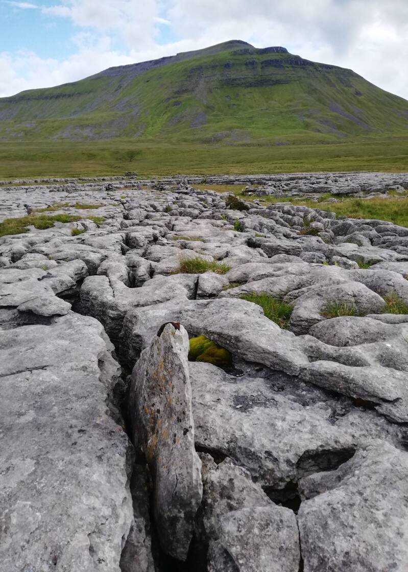
Photo below: The author stood next to a large cairn located around Raven Scar on Ingleborough. I have heard some say that the origin of this cairn is more recent, but on the other hand its design, certainly, and its method of building, is akin to that of several ancient cairns in northwest England. This photo was taken by a family member, whilst the other two photos were taken by me, the author.

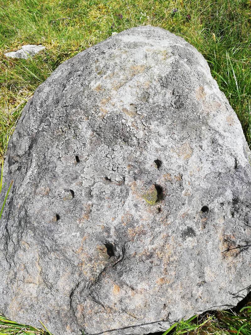
Photo below: a stone with an almost vitrified appearance, located within an area of ancient walls some way from Raven Scar on Ingleborough. The holes in this rock appear not to be cup marks, but rather belong to a strange erosion process or change which has resulted in these holes. Similar stones, I have noticed, with this same vitrified appearance, exist elsewhere in North Yorkshire, as I discussed briefly in relation to the megalithic alignments at Cowside in an unrelated blog post to this. Another of these stones is located at the possible archaeological site I found across the river from the Halton Gill Giant's Graves, whilst another is found approximately southwest of the Halton Gill Giant's Graves (the aforementioned are discussed in two different blog posts), over the streambed and over the road. It seems that some of the ancient cultures in North Yorkshire chose rocks of this type specifically to incorporate them into alignments and into meaningful settings. Alternatively it implies some other connection between many of these ancient prehistoric groups in North Yorkshire and the use of rocks of this particular nature. Again I am not implying that these rocks "are" vitrified, rather that they have a vitrified appearance.
There are also ancient cairns and evidence of settlement on the top of Ingleborough, as well as cairns and other interesting sites on the southern and eastern slopes of the mountain. On the eastern parts of the mountain, below the main mesa or plateau, is the top of Gaping Gill, a cave, arguably more of a chasm in the ground, that leads into the bowels of the mountain. This is 322 feet deep. The lower parts of the chamber are filled with sand-like sediment, and below that, with boulder rubble. This cave must have held an incredible significance to the indigenous people around the mountain, perhaps being seen as some kind of primary window into the greater Underworld beneath the mountain. It would indeed be interesting to see if there are also stone alignments around the top of Gaping Gill, which might suggest alignments and/or trackways connected to it and to other caves in the area.
Ingleborough could also be associated in some way with the goddesses Brigantia and Brigid, the first of which is also the patron goddess, and name given by some to the upland peoples of this region in Roman times. The use of the word ingle may imply that some in this region, associated this word with a similar kind of holy fire to that associated with Brigid. That the word ingle seems to connect to Goidelic influences, possibly local to the area, is also interesting, given the other things I have discussed elsewhere regarding legends of giants and connections between this region and the Goidelic and pre-Goidelic worlds. We can safely assume for sure that this mountain would have been associated with gods, sacred figures, or ancestors in some way, perhaps with individual gods and spirit beings. And perhaps ingle is not just a descriptive term, but relates to an older extra-Goidelic language presence in the area. Whilst Scottish Gaelic aingeal also means "angel" and is thought to come from Greek, via Latin, we also simultaneously have the Goidelic meaning of "fire", which could imply in some way, in my opinion, that to some degree, this element might pre-Latin and even pre-Celtic in origin.
I hope that this article was an interesting read. In the next few days, possibly even tomorrow, I will be publishing another article/blog post on this website about the Great Asby Scar stone arrangements and the Castle Folds settlement site nearby, I mention in this article in front of you the Great Asby Scar stone arrangements, briefly. I may also publish other unrelated blog posts and articles before publishing the aforementioned upcoming article, but am unsure yet. I will certainly be publishing another article today after the one on this page and the previous one on this website, the third one will be published on a different website. This article/blog post is dedicated to my family and to the ancestral forces which protect and reside around Ingleborough. Not that Raven Scar discussed in this article, with its stones placed into cracks in the limestone, is unrelated to Great Asby Scar which has different sites where similar but unique arrangements of stones occur. Update - Castle Folds and the sites on Great Asby Scar will instead be discussed with photos in an upcoming unrelated PDF-only book which I will publish on a different website to this. I hope that this article on this page was an interesting read.
Add comment
Comments