Written and published by Linden Alexander Pentecost. This article or blog post is unrelated to any and all of my other publications. This blog post/article was published on the 13th of February 2026. This post was published in the UK and only on this UK website, even though some of the things in this publication are mentioned in a different way in my other publications, The author is also from the UK and lives in the UK. No AI was used in this publication. The three photos in this publication showing the fish traps and surroudings were also taken by myself the author. The photos have not been published before and are important, as are the photo descriptions above each photo which contain information not in the main text. This article/blog post contains 1668 words. Note that the sea is dangerous, and although the photos in this article show it as calm, it is very easy to get cut off by the tide in this location, and is very often not so calm weather. When the weather is even slightly rougher it is very easy to get cut off by the tide there, so take great care if visiting this coastline. Kokoarrah cannot be walked to at low tide either.
On the coastal area between Drigg and Ravenglass in West Cumbria, there is a large sandy beach. A short distance out to sea, is a wee skerry or possibly a rocky glacial deposit called Kokoarrah, a roundish expanse of rock that sits just above the surface, although I would not be surprised if at times it becomes completely inundated by the sea. Kokoarrah is similar in form to King's Scar close to Fleetwood in Lancashire, King's Scar possibly representing what I think could be part of an ancient bank or system of raised glacial bands between Fleetwood and the south of Walney Island. Like Kokoarrah, I think it could represent a part of an ancient, inundated landscape.
On the rocky shoreline opposite Kokoarrah, and below the sand and dunes, is an area of the beach at Drigg which is very rocky, like Kokoarrah, and on this rocky area of beach, are what appear to be ancient fish traps.
It is hard to estimate how old these fish traps are, because the coastline of Cumbria has "shifted" enormously in the past 20,000 years or so. Melting ice, the uplift of the land, and human activity have helped to influence this, whilst folkloric evidence in Lancashire suggests that at least two tsunami events have also happened, and I think it possible there have also been others. Whilst the coastline of Cumbria today is relatively stable, it was not always like this. At times, during the so-called Ice Age, sea levels were generally much lower. When sea levels rose, the northern coast of Cumbria became largely inundated, and has slowly risen again, and in the north of Cumbria this process is at least somewhat observable. It also helps to explain - in my opinion, why there seem to be fewer ancient place-names in North Cumbria and fewer archaeological sites.
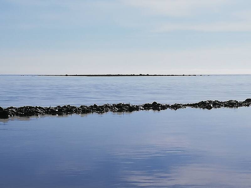
Photo below: the bank of Kokoarrah visible a short distance across a calm, late spring sea, the longest fish trap wall being visible below it and nearer to where the photo was taken.
In the south of Cumbria, the picture is far more complex, with Morecambe Bay for example having gone through periods of being a landscape of wetlands, lagoons and low forest, to a landscape that was inundated by the sea in the north but not in the south. At certain points, sea levels in southern Morecambe Bay rose much higher than their present levels, meaning that the sea came as far inland as Rusland not far from Grizedale Forest, and as far inland as Brigsteer to the east. Sea levels have since fallen and have stabalised around their present levels, although man-made embankments have also greatly influenced these landscapes in more recent times.
Because the beach opposite Kokoarrah is quite centrally in west Cumbria, it is possible that sea levels could have changed less in this region, because whilst north Cumbria has been more subject to post-glacial rebound, and in addition, the other, less-understood processes of inundation and possible tsunamis seem to have affected southern Morecambe Bay and the Fylde more than west Cumbria, although since I am not sure on any research into past sea levels in the Ravenglass area, I cannot really say. Their design is similar to that of fish traps used by some of the Mesolithic peoples in the UK, and I think it likely that culturally speaking, and perhaps linguistically speaking, the people who built these fish traps near Kokoarrah may have been connected to some of those we identify as Mesolithic populations, except I do not personally think that they really died out, rather I think they simply became a minority in this landscape, considering also that their population density was not that great anyway in all likelihood. This can be evidenced by the fact that similar fish traps were used in Britain into recent times, among a lot of other evidences and implications.
Many of the ways of coastal communities in Britain, many of our words for coastal animals and plants, and many of our ancient fishing methods, could I think, have been shared in some way with Mesolithic populations. For example, many words for marine fishes and invertebrates in English and in Celtic languages are of uncertain origin, which could imply they came from smaller, ancient populations of coastal peoples.
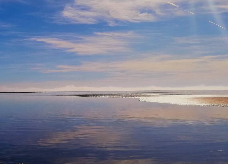
Photo below: a mysterious sea mist coming across the sea towards Kokoarrah and the coast, with Kokoarrah visible on the far left as the black area of rocks, the mist can be seen behind along the whole horizon of the sea, and invoked for me the imagery of mystery, and of ancient times when Cumbria was connected to the Isle of Man and to Ireland, and with the Manx god Manannan having been known to have cloaked himself in mist. Was Manannan perhaps approaching Cumbria when I took this photo? This was certainly the eerie mystical feeling that I had.
The fish traps at Kokoarrah are between the middle and lower shoreline areas, and it is possible that they are in a similar position on the level of the beach to that which was intended by their builders. Fish traps in these lower shore areas are effective, provided that the tide goes out far enough. Although I am inclined to wonder whether or not these traps were originally positioned slightly higher in relation to where the mean low tide level was. Although the original effectiveness of these fish traps in their original position relative to the sea, would also depend on how exposed the coastline was, or whether in fact Kokoarrah was once larger, sheltering the beach further. These fish traps could even have been created originally on the side of a rocky lagoon with less tidal influence, or upon a previously existing river channel.
The nearest river channels to Kokoarrah are the mouths of the Esk, Irt and Mite rivers, and of course, these rivers would not always have reached the sea along their current courses. Only by answering all of these questions can the age of the fish traps be determined, unless of course, someone finds for example a flint tool or axehead in a sound archaeological context within the walls of these structures. Such research would of course require all of the correct permissions, and as my readers may know, I am very against any unnecessary damage to archaeological sites, particularly when it concerns burial sites.
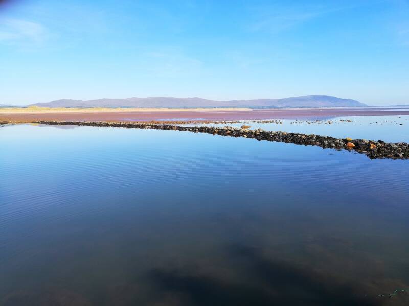
Photo below: a view of the largest of the fish trap walls, partially covered by the tide still, going up the beach a fair distance, with the mountain of Black Combe visible as the mountain on the right, close to the sea in the distance.
On a side note, within the sand dunes nearby to this site, was found an ancient stone tool-making site, which was used in the Neolithic and Bronze Ages. It is likely that during this period, western Cumbria would have had very close contact with Ireland and the Isle of Man. I even think it is possible that the name Kokoarrah itself is from the language of these peoples. I have written a lot elsewhere on different aspects to this, but, essentially Kokoarrah is a word of unknown etymology. The first element could be in some way related to the Celtic or extra-Celtic root *kogr-, which is also found in the place-name Cockerham. This root word implies a twisting or winding movement, and is I think related to the English word "cog" and to other cognates within Germanic. The -ah element is harder to interpret. It may be connected in some way to Anglo-Norse á - "a stream", or to the Goidelic suffix -ach/-each, or -agh in Manx. This -ah suffix occurs on a few other place-names in West Cumbria, and I do think that something similar to the aforementioned Goidelic suffixes is possible, but is unproven.
At the time that the stone tool-making site was used, I doubt that the dunes would have been here, at least not to the same extent. I met a guy in West Cumbria last year called Michael O' Connell, and he told me that when fishing around Ravenglass Harbour in the past, he found what he thought looked like the remains of a Roman harbour wall, which is another point of interest, and which also helps to demonstrate the longevity of ancient activity in this area. I have also mentioned this in a few other publications.
I hope that this article was an interesting read. It was written in honour of my beloved family, and of all fisherfolk, sailors and sea folk, and all who love the sea.
Add comment
Comments