This blog post was written and published by Linden Alexander Pentecost, and was published (after two unrelated mine-related blog posts published on the same day) on the 16th of November 2026. No AI was used in this publication and I the author took all of the important 9 photos included in this publication. This post was published in the UK and contains a total of 2024 words. Note that the mine in the photographs in this blog post is nolonger accessible, and note that mine exploring is extremely dangerous and that I am not encouraging it.
Kentmere is a fascinating valley. I know some people who say that the valley has a dark, oppressive feeling in a way. I do not feel this, and I do not think that they are referring to any kind of feeling of evil - more a feeling of being enclosed, watched, but also I feel - protected. The valley does not boast the same level of identifiable prehistoric sites as many other valleys in the Lake District do, but there are nevertheless ancient features, with some that could perhaps be prehistoric megalithic sites. Because Kentmere, particularly around its village, is strewn with large boulders, it is hard in a sense to identify ancestral influences - but I believe they are present, in the forms of what seem to be stone rows, possible megalithic alignments, large clearance cairns and possibly other cairns, as will be shown in the photos in this blog post and discussed in each photo description above each photo.
The question of ancient slate extraction in the valley interests me greatly. The upper part of the Kentmere Valley boasts many slate mines and quarries, most of which were at least partially underground. The slate vein dips incredibly steeply in this valley, and at Wrengill quarry to the east and at the Troutbeck Quarries to the west, meaning that sometimes the slate caverns tend to be rather tall and narrow - rather like some of those on the "narrow vein" slate vein at Corris in Mid Wales, only, the chambers in the Kentmere slate mines are like a thousand times smaller than some of those around Corris.
Dating some of these sites seems extremely difficult. One of the quarries, called "Cauldron Quarry" is very impressive, and appears as a large "hole" beneath a steep crag rising up the mountain. Below the quarry is a slate tip, a steep scree slope, within which can be seen the remains of a track used I believe by those transporting the slate down the scree on sledges. This site is generally connected to the 1800s, the quarry having been thought to have started operations before 1850. I am not sure though, the working methods of this quarry/mine and the fact that it is a typical "cave working" would make it a rather unusual method of quarrying (for a new quarry started in the 1800s), although it is possible that the "cave working" method was used here, in extension of ancient local working methods and due to the "cave working" method being ideal for the particular location of this quarry.
Note: "cave working" refers to a method of Cumbrian slate mining that begun before the 1800s and is generally considered to be a pre-1800s method of mining, hence why the use of a cave working method at Cauldron Quarry is somewhat unusual. Could the quarry actually be older? Note also that I have described in more detail how the "cave working" mining method worked in some of my other publications. Generally these cave workings became unstable and collapsed, with Cauldron Quarry and Rydal Cave being two well-known surviving examples (neither of these are inherently safe and Cauldron Quarry has suffered significant collapses of large boulders from the ceiling - and Rydal Cave may also experience this in the future - hence why it is important to note that Rydal Cave is not safe).
Other slate mines at Kentmere show other working methods, usually a mixture of open quarries and adits leading to underground chambers of "closeheads", although some of these open quarries may originally have been cave workings. Steel Rigg Quarry/Slate mine for example shows an open quarry that dangerous connects to largely collapsed underground workings, and it is possible that the open quarry was once an underground closehead, opened to the surface and intersected from a level below.
The strangely named Jumb Quarry is perhaps the "largest" slate mine in the valley, and consists of three distinct levels, all of them mined as open quarries, and each with a level. The lowest level/adit is wet and leads nowhere. The middle level was explored by someone I know, before it was gated. He described impressive closeheads of a fair height, with areas of Matt Spedding tunneling (a kind of Cumbrian slate mining tunnelling method using drystone masonry through backfilled closeheads) - which is supporting a lot of weight and which is unstable. When this friend of mine left that level he said that he and his mates heard a large "crash" and rumble as presumbly a part of the Matt Spedding tunnel or other part of the mine roof experienced a collapse. This is an important thing to tell, both for making a record description of this level and for highlighting the dangers - slate mines do experiences terrifying collapses, are very dangerous, and I have experienced one myself which happened only a few metres from me. Thankfully I was fine. I was only 16 at the time.
The upper level of Jumb Quarry is also gated off now, but back in around 2012 and 2013 it was possible to crawl under the grill across the wide entrance, although when I last went to this site in 2019 this was nolonger possible. Since I was probably one of the few people to visit that level in decades and because it is now inaccessible, I feel that my record of the site and photos are important. The photos of this mine appear beneath the photos of potential ancient archaeology sites in this article. Below are the photos, each with an extensive description above.
Photo below: stone-row type feature located behind Kentmere Village church towards Pengennett, in an area of extensive clearance cairns of unknown date. I do not know the exact location but these rocks are located behind a farm and are I think nevertheless important to record. This photo is taken looking up valley and from the west side of the valley, not far from Kentmere Village. Many of the nearby cairns contained mixtures of larger boulders and smaller stones between them, they could be more recent, I suspect that in part some of them are, but they are also reminiscent of prehistoric, Bronze Age clearance cairns. After the photos there is also another short section of writing which is not a photo description.
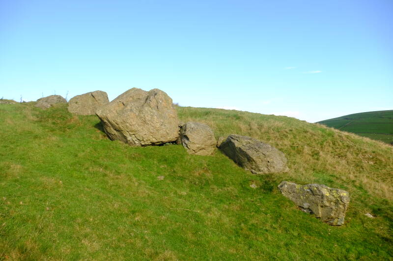
Photo below: slightly to the east from the photo shown above (the farm in question mentioned above the photo above is I think that one visible in the distance and on the left in the photo below, with the cairn sites and site photographed above on the green hill to the right of the house). The photo below shows an area nearer to the centre of Kentmere village, wherein are many large boulders, some of which are also formed, it seems, into clearance cairns, of unknown date. Some of the groups of boulders also look similar to stone rows and certainly some of their positions have been altered by people I think, whether in ancient or medieval times.
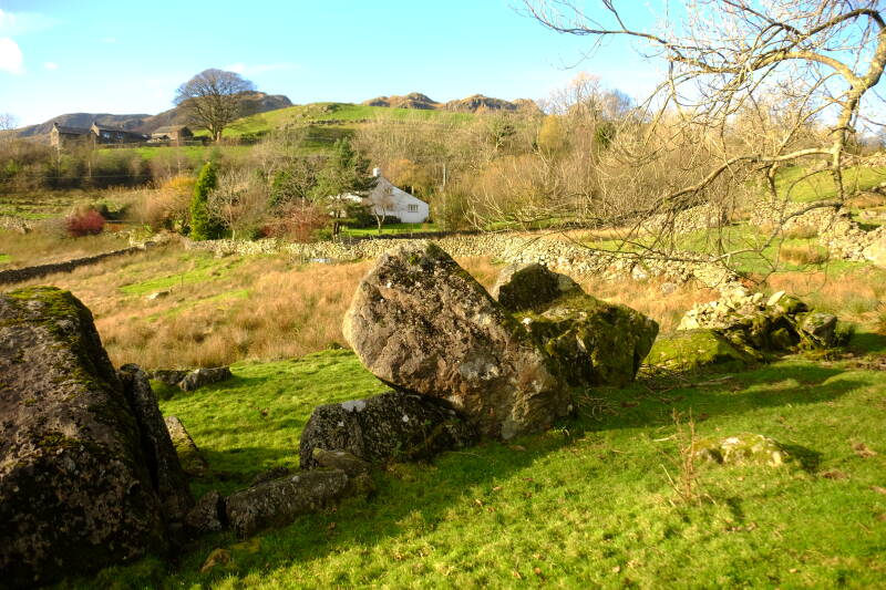
Photo below: another cairn-like structure slightly up valley (perhaps 300m northwards upvalley from where the photo above was taken). The example below looks similar to some of those below Warton Crag, and is indeed very much of the same style, note the large boulders and smaller stones for infill. It is also possible that if some of these clearance cairns are prehistoric that they could simultaneously have served as burial cairns or as sacred sites.
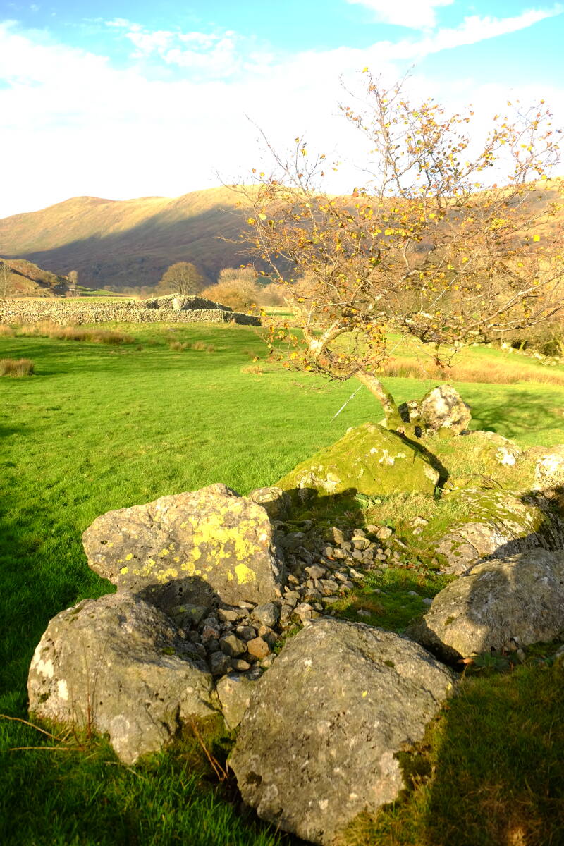
Photo below: a curious rock feature, possibly a man-altered or ancestor-altered propped stone feature upon a cairn, but it may also be natural, I am posting it here to document it either way. It is located at approximately the coordinates: 54°27'19.7"N 2°50'45.7"W , if my memory serves me correctly, and is further upvalley from where the photos above were taken.
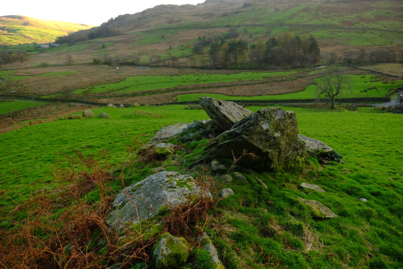
Photo below: part of a known prehistoric or medieval circular enclosure feature located a short distance west of where the photo above was taken, to my knowledge. The structure consists of, as with many other prehistoric sites in the area - a wall or embankment made of small cleared stones, and flanked by, and having within it, megaliths, although the ones at this site are not huge. The unusual thing about this structure is that it is circular.
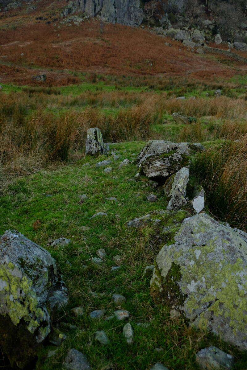
Photo below: the uppermost closehead at Jumb Slate mine, taken in 2013, note the beautiful colours of the rock, somewhat "verticalness" of the chamber and the impressive drystone wall to the left, which may well have collapsed now. Despite this upper entrance being the uppermost part of the workings, one could go upwards a short way, and also climb downwards, where clearly Matt Spedding tunnels connected to further chambers. The photo below shows what may in fact be the middle "level" as I approached it from the uppermost level and entrance, the remnant of the Middle Level (or intermediatory level) as the clear, cutting shaped area in the centre of the photo, leading to the Matt Spedding tunnel entrance which can be seen in the distance below the potential entrance in the roof above. The Matt Spedding tunnel entrance can be identified as a wooden support visible at the end of the cutting. This is now blocked but may have lead into the areas where my friend visited on the Middle Level, the level where, having left the level, he heard a collapse.
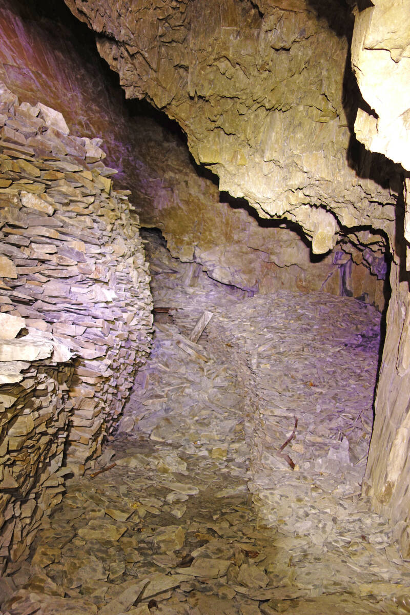
Photo below: the entrance to the Matt Spedding tunnel described in the description above the photo above. Note how the retaining wall to the right is bowing outward and how the tunnel is collapsed after a short distance.
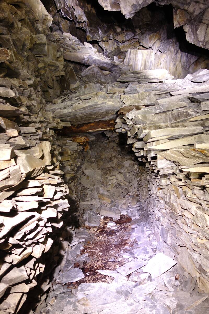
Photo below: a selection of what appears to be some partially-worked slates, abandoned in one of the upper working areas connecting to the upper level entrance. In Cumbrian slate mines it was common in the past to actually dress the slates underground, especially in earlier times and where the working areas let daylight in. This was a special archaeological find.
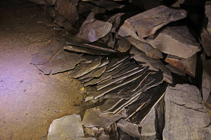
Photo below: a working area slightly above the uppermost entrance at Jumb, with daylight shining through in the distance. Note the backfilled areas to the right and left which could well have served as areas for working roofing slates.
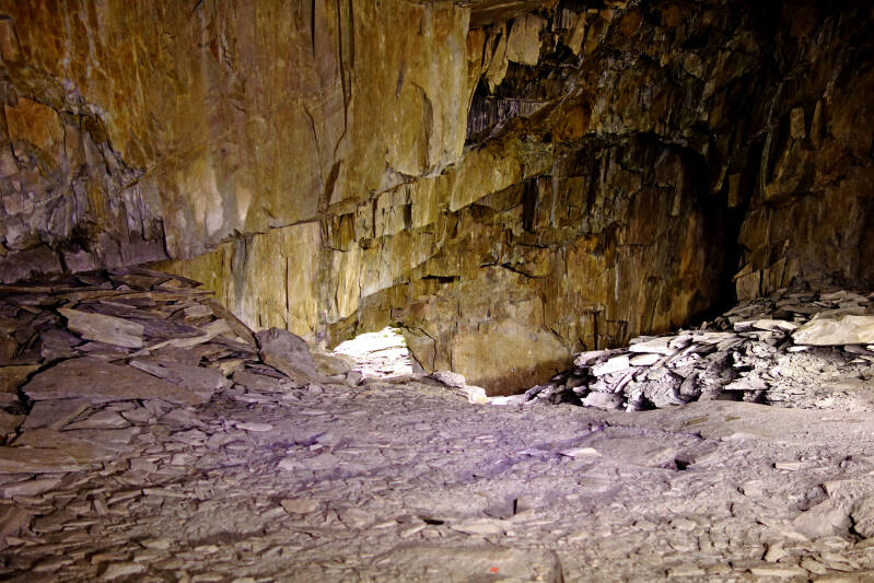
Jumb Mine is now entirely inaccessible, and these may be the only pictures ever published online of the interior of this mine. The other slate mines around Kentmere are also dangerous, and should only be visited by professionals who truly know what they're doing. The risks in slate mines are also often very different to, but sometimes similar to, those in caves. I do plan in the future to publish about some of the other slate mines around Kentmere, and I have not explored all of them. But I do not know when I will be able to travel back there. There are some interesting slate workings (presumably surface) on the eastern side of Ill Bell, I visited these before, and the area around there, whilst steep and dangerous to explore, could, for sensible individuals, be a place to potentially look for evidence of more ancient slate quarrying. The same applies to some of the outcrops between Kentmere and Longsleddale. Note I have also discussed Wrengill slate quarry in Longsleddale in one of my early blog posts on this website, and the wizards that were said to be in Longsleddale, and which perhaps still are.
I hope this blog post was a fascinating read and is useful for archaeologists.
Add comment
Comments